Mae Hong Son province has another name ‘the City of three mists’ because it is surrounded by high mountains with cold temperatures and covered with mist all 3 seasons. The city is rich in the beauty of natural resources – mountains, forests, and Flowers leading the city to one of the must-see cities in Thailand.
For those familiar with the name, Mae Hong Son conjures fantastic images of rugged, mist-enshrouded mountains where isolated tribal villages await exploration. From the fascinating Culture of the indigenous tribal communities to the spectacular natural beauty of the countryside, Mae Hong Son is certainly a dream-come-true destination for many visitors.

Nestled in a deep valley hemmed in by high mountain ranges, Mae Hong Son town has long been isolated from the outside world. Virtually covered with mist throughout the year, Mae Hong Son was once only accessible via harrowing, windy, narrow roads that took most of a day to traverse, an adventurous drive that made the town that much more alluring.
The name Mae Hong Son refers to the fact that its terrain is highly suitable for the training of elephants. Former governors of Chiang Mai used to organize the rounding up of wild elephants which were then trained in Mae Hong Son before being sent to the capital for work. Elephants remain an important part of the Local Culture, and elephant Trekking is a popular tourist activity, often combined with overnight hill tribe homestays and River Rafting.
Mae Hong Son is a fascinating province of Burmese and Lanna-style temples, hot springs, hill tribe villages, Trekking, Rafting, national parks, and even an annual reggae festival. In addition to being a charming capital in Mae Hong Son town, the town of Pai is also a traveler favorite; many people come to Mae Hong Son and Pai to experience the natural beauty of northern Thailand or witness one of the many festivals that are celebrated in Mae Hong Son, especially the annual novice ordination ceremony for young men declaring their intentions to become Buddhist monks.
Pai, Mae Hong Son: Thailand’s Mountainous Gem
Pai, in Mae Hong Son province, started to gain recognition in the late 1990s as a small city worth visiting when all thousands of curves en route from Chiang Mai were a challenge and often scared anyone prone to motion sickness when road conditions were worse than what they look like today.
Yet its irresistible charm as a charismatic compact town in the valley with cultural dominance and natural grandeur prompted this gem destination to its stardom, firmly well-positioned on the international travel map.
Bordering Myanmar, Mae Hong Son is the most mountainous province in Thailand that is still underdeveloped. Thanks to the tourism boom, many areas in the province including Pai have been benefiting from a growing number of visitors. Even though Pai is popular among tourists, it still has charm being an off-the-beaten path and a slow-life destination. However, the province still remains relatively exclusive due to it being hard to travel to.
Pai sits in a valley on the banks of the Pai River, about 146 kilometers northwest of Chiang Mai. It was once a small market village inhabited by ethnic Tai people from the Shan state whose culture is influenced by Myanmar. Primarily thriving on tourism, the town is full of affordable guesthouses and souvenir shops. Currently, a huge number of overseas visitors still enjoy the laid-back ambiance Pai has to offer, with most of them extending their travels from Chiang Mai to indulge themselves in the foggy morning, confirming the nickname of Mae Hong Son province as the ‘city of three mists’ surrounded by high mountains with cool temperature all seasons, and linger their socializing as the pulse of Pai starts beating faster when its renowned nightlife gets uncovered after twilight.
With unspoiled natural resources – mountains, forests, and flowers – and multi-faceted heritage, coupled with the contrasting pace of living during the day and nighttime, Pai can leave visitors spellbound, carefree, and lost in time. Known for its leisurely atmosphere suitable for young and seasoned travelers who want to get away from a bustling schedule and indulge themselves in the slow living ideology. This lovely small town can be visited all year round, with the cold season being the most popular and crowded time from November to February. An earlier visit from late August, which is in the middle of the green season, is acceptable as well since the rice paddies often reveal their brightest shade of green while natural surroundings offer something different from the peak season.
Make your way to Pai, and you will witness the town at its peaceful moment. Though the tiny town now turned into a famous and busy destination, you should spend a calm night here in some of the quiet accommodation outside the town. The town’s nature and vibrant art scenes will introduce you to a memorable side of this town.
#Let’sGoPai
Tham Lot Nature And Wildlife Education Centre
Mae Hong Son
Located in the Tham Lot Subdistrict, about 77 kilometers from the city of Mae Hong Son. It is an important archaeological site under the administration of the Lum Nam Pai Wildlife Sanctuary. There is an interesting cave called “Tham Nam Lot,” where Nam Lang Creek runs from the cave mouth to the other side of the mountain, resulting in beautiful formations of stalagmites and stalactites. The discovery of ancient tools and utensils at the site proved that the cave is around 2000 years in age. Inside the cave, about 1 kilometer long, consists of three huge rooms, called by different names. “Tham Sao Hin Luang” is a large cave full of beautiful stalactites and stalagmites. The most prominent feature is a few large limestone pillars of up to 20 meters. “Tham Tukkata,” the most expansive and longest cave in Tham Nam Lot, is lined with small stalagmites, shaped like dolls of different sizes. There are distinctive prehistoric paintings in red and black colors on one side of the wall, something which is rare in Thailand. The last cavern on the exit side is called “Tham Phi Man.”, which besides having beautiful stalagmites and stalactites, has also offered up remnants of earthenware, grains, stone tools, human teeth, and even bones. Various sizes of “Men’s Coffins” or wooden troughs for feeding pets lie inside the room. The large coffins are placed on beams using 4-6 columns to anchor them to the ground. Each pair of pillars has a cavity so the beams can be inserted and placed over the men’s coffins. Due to the exotic subterranean wonder of darkness and mystery of the cave, visitors require a skilled navigator equipped with a storm lantern to guide them through, and these are available at a charge of 150 baht per navigator/group. The walking tour is divided into two sessions; visiting Tham Sao Hin Luang and Tham Tukkata and then visiting Tham Phi Man. Tham Lot Nature Study Centre is Open daily from 8.00 – 17.00 hrs. Accommodation and facilities: The center offers lodges and campgrounds. For further details contact, the service unit within the Tham Lot Nature Study Centre, Tel. 0 5361 7218
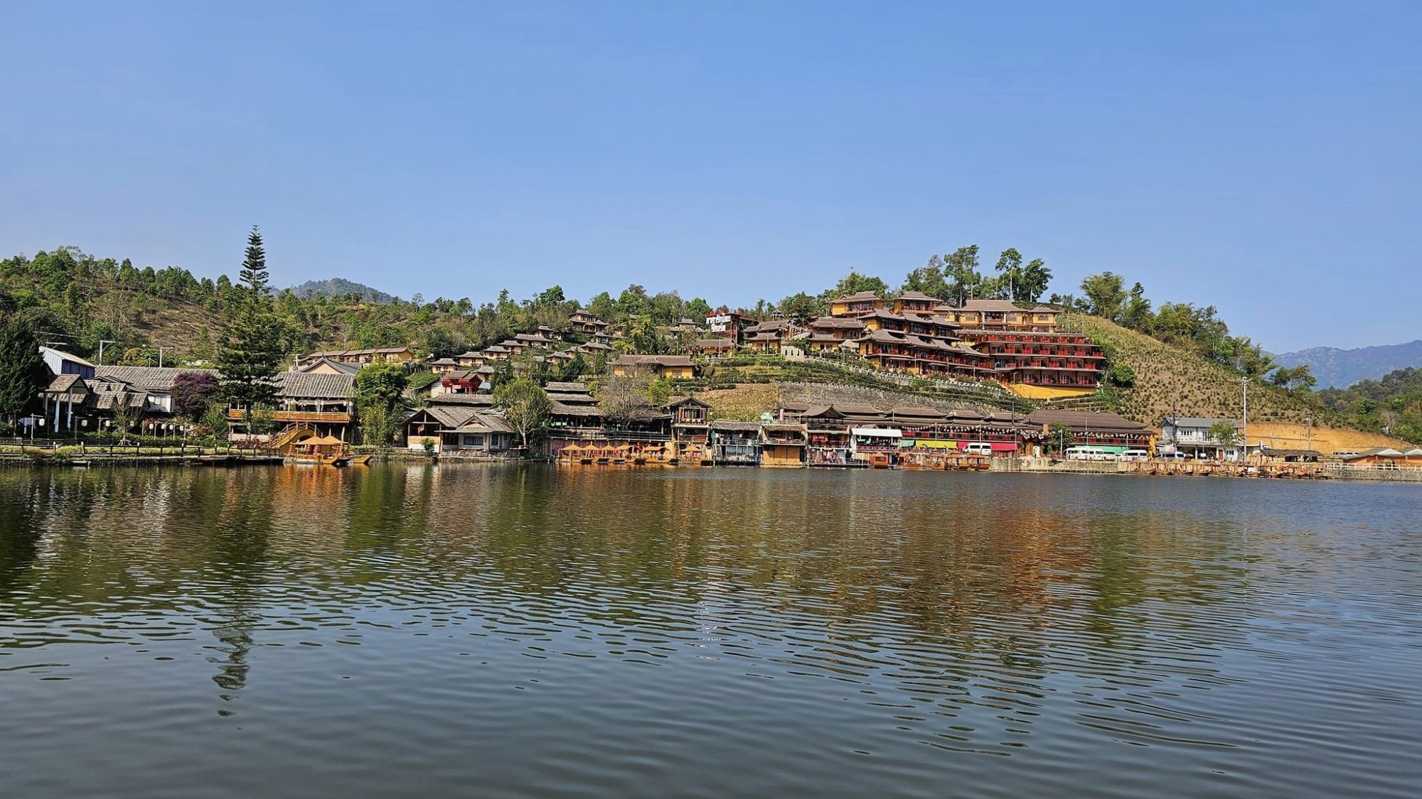
“Ban Rak Thai” for the European recommend to think about “Hallstatt”
Ban Rak Thai or Ban Mae O is the last village before reaching the Thai-Myanmar border, situated 44 kilometres from Mae Hong Son, via Pha Suea Waterfall in Mok Cham Pae Subdistrict. Most of the villagers here escaped from southern China during the emergence of the communist regime. Apart from a beautiful lake, tourists can explore the way of life and Chinese culture, which still exhibits many traditions in terms of both spoken and written language. The distinguishing feature of the Ban Rak Thai village houses is the old-style materials that were used in construction: namely clay mixed with rice straw. You can also enjoy traditional Yunnan foods and taste delicious teas of the many top varieties, which are on sale in the village, including Qing Qing tea and Oolong.
Mae Sariang is not very big, so you can easily get around walking or renting a bicycle (50 baht/day) from one of the local guest houses. Motorbikes are available for around 200 baht a day as well.
For longer journeys out of the town, you may want to hire a car and driver. Ask any of the local guest houses and they may be able to arrange this for you.
For those who are in Mae Sariang in November: Try your level best to visit Mae U Kho, which is about 2-3 hours away. During November, the hills and valleys of Mae U Kho, one of Thailand’s most naturally scenic areas, turn to gold when the Dok Bua Tong (Giant Wild Mexican Sunflower, Tithonia Diversifolia) comes into full bloom.
Mae Sariang, beyond offering visitors areas of exceptional natural beauty and insights into traditional tribal ways of life, has some notable ancient holy sites where tourists are welcome to join the locals in paying their respects for good fortune and prosperity. These sites are together called the Phra That Sii Chom (The 4 “Chom” Reliquaries). The “Wat Prathat” prefix denotes a temple that is believed to house a relic of the Buddha.
Karen & Lawa Hilltribe Villages, [x]. One of the cultural highlights here is the authentic hill tribe villages scattered all around Mae Sariang. They will not be signposted so may be difficult to find. Thailand Hilltribe Holidays offers guided tours (trekking and by car) of the area. Specializing in responsible travel to the villages and cultural immersion into the local way of life.
Burmese roof architecture of Mae Sariang Museum
Wat Pra That Chom Gitti. Outstanding stupa in typical Lanna design. On the 8th day of the first half of the 9th lunar month (around June), a celebration is held here. Free Entry.
Wat Phra That Chom Mon. Northern design, with a festival in July. Impressive murals of Lord Buddha’s life, painted by local artists. Free Entry.
Mae Sariang Museum, (At the intersection of 108 and 105). Unfortunately, the museum has fallen victim to a fire (Late October 2015) and is not open. Reconstruction dates are unknown. The burnt remains of the structure can be seen from the 108. The museum was a single-story raised wooden building with a design that blended traditional Thai Yai wood carving with northern Thai architectural styles. It was a center for the display and sale of One Tambol One Product (OTOP) products, and featured presentations about the way of life of tribal peoples including Lua, Thai Yai, Karen, Lawa, and Hmong along with local history. It also had plenty of information for tourists about sites throughout Mae Hong Son.
The Old Police Station at Tha Ta Fang
Refer to the website World War 2 North Thailand
In March 1944, the Imperial Japanese Army (IJA) attempted an invasion of Imphal and Kohima in India. By July, it had been driven back into Burma, suffering its worst defeat to that point in the war. 3 In the months after, the retreat back into Burma evolved into a rout. Numbers of IJA troops pushed south towards Rangoon. A significant number of them turned east towards the land of Japan’s ally, Thailand. And most of those were funneled into the Thai border district of Khun Yuam.
However, numerous local cross-border trails existed, as well as long-established trade routes, with connections to points other than Khun Yuam. One of those used by retreating IJA troops tied Papun in Burma to Chiang Mai in Thailand
It crossed the Salween River as shown at Dagwin on the Burma side with Tha Ta Fang (not here labeled) facing it in Thailand.
On the Thai side, overlooking the trail where it crossed the Salween River at that time was this structure which still stands today
Most likely, IJA troops following this trail saw the building, and some may have stopped overnight in it, though it would have been an exhausting climb for most who were starving, wounded, or suffering from malaria — or, often, afflicted with all three. Thai Police manned the station during the war. There is no evidence to suggest that the IJA assigned personnel there. Since the border at that time ran between friendlies — Japan-occupied Burma and its ally, Thailand, there was no justification for allocating IJA troops there during the war.
Nonetheless, the building is today called the “Japanese” building/fort/station by tour boat operators, perhaps recalling Japanese war veterans who passed through the area in the late 1970s looking for remains of IJA troops. Guides may justify the name by saying that the IJA built the structure during the war. Those veterans passing through here 40+ years ago were probably ferried by the fathers of the current boat pilots. The veterans sketched their access to the area
Their approach to the site, via the Saween River from Mae Sam Laep, is the same as that most often used by tourists today. The veterans, however, were concentrating on recovering the remains of IJA troops who were rumored to have been buried in the area. Their journal mentions Tha Ta Fang’s police post and recalls that it was there during the war.
The building was actually erected in 1901, and financed by locals who were trying to encourage the Thai government to protect them from Burmese bandits. It is not known if contributors included the great logging companies working in the area at that time. If so, that would be evidence of the lawlessness of the times in that area. The station was manned continuously from its construction in 1901 through to 1981, when the office was moved to a new building, closer to the town. 9
A current view of the front of the old station
Some comments about the Mahaphon photo help explain the station building at Tha Ta Fang:
. . . the police station was built as a two-story fortress so as to repel marauding criminals. The four sides of the ground floor are entirely covered with wooden boards which have gun ports. From the front, there is only one narrow set of stairs so that only one man can up or down at a time. The police officer upstairs is able to see whether the suspect carries a weapon or not. There are holes on the second ground floor for the light coming through the downstairs – not completely dark. The ground floor is also used as a supply storage of food and weapons.
At the Tha Ta Fang structure, the staircase is wider — enough to accommodate two people. There are no holes in the second floor to allow lighting on the first floor. However, gun ports penetrate the walls in profusion on both floors. While the wall thickness for the Mahaphon station is not recorded, that for Tha Ta Fang is about 14 cm (5 1/2 inches)
The buildings testify to the needs of a different time, for security against armed attack not experienced today in Thailand.
In military science, a blockhouse is a small, isolated fort in the form of a single building. It serves as a defensive strong point against any enemy that does not possess . . . artillery. . . . [They] were constructed for defense in frontier areas . . . [and were once] commonly made from very heavy timbers . . .
Blockhouses [now of concrete] have become a feature of the conflict in Afghanistan, being used as strong points to control the contested Southern provinces. . . .
While a newspaper article observes deterioration of the wood in the Tha Ta Fang structure, 14 it is still remarkably sound after 110+ years. The lack of initials carved in the wood suggests that the teak is still very hard. And that teak continues to prosper despite severe deterioration of the metal roof and resulting exposure to the weather.
Credit: https://www.ww2norththailand.com/mae-hong-son/tha-ta-fang-old-station-house/
Mae Hong Son Key Tips
1. Those who are susceptible to motion sickness should take medication before setting out on the long, winding old road to Mae Hong Son.
2. When visiting Pai during long holidays, especially in winter, it is recommended to get an advanced hotel Booking.